LUANG PRABANG AND AROUND

Anchored at the junction of the Mekong and Nam Khan rivers, the former royal capital of Lane Xang is now a UNESCO World Heritage Site. It is home to a spell-binding array of gilded temples, weathered French colonial façades and art deco shophouses. In the 18th century there were more than 65 Wats in the city. Yet for all its magnificent temples and absorbing atmosphere this royal ‘city’ is now becoming an ersatz ‘tourist’ village. The entire historical centre appears to resemble one giant ’boutique’ hotel/coffee shop and few buildings are now used for anything except to service tourists.

With rents and costs spiralling the local Laos population are now disappearing from the centre of Luang Prabang and even the scores of monks who used to leave the monasteries every morning to collect alms from the town’s residents have been rumoured to be struggling to sustain themselves. One solution to this has been several shops selling extortionately priced, ready-made bags of food as ‘monk’s offerings’ at so that the snap-happy tourists can get the requisite photo of a saffron-clad monk walking in the mist.
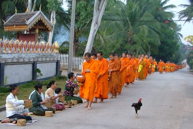
Monks in Luang Prabang - LUANG PRABANG AND AROUND
Monks in Luang Prabang

Another factor lurking in the background are the Chinese, who seem keen to pour in money to help develop Luang Prabang, with a huge airport and urban developments being mooted. There’s no doubt that Luang Prabang is undergoing massive changes – the struggle will be to keep at least some of the original atmosphere and develop a sustainable future. The famous Pak Ou Caves and the Kouang Si Falls are located near the town.

Getting there

Flying is still the easiest option with daily connections from Vientiane, plus flights from Bangkok and Chiang Mai to Luang Prabang International Airport (LPQ).There is a standard US$2 charge for a tuk-tuk ride from the airport to the centre.

Route 13 is now safe, with no recent bandit attacks reported, and the road has been upgraded, shortening the journey from Vientiane to eight or nine hours. There are also overland connections with other destinations in northern Laos. Luang Prabang has two main bus stations:

Kiew Lot Sai Nuan

(northern bus station), located on the northeast side of Sisavangvong Bridge, for traffic to and from the north; and Naluang (southern bus station) for traffic to and from the south. Occasionally buses will pass through the opposite station to what you would expect, so be sure to double-check. The standard tuk-tuk fare to/from either bus station is 15,000 kip. If there are only a few passengers, it’s late at night or you are travelling to/from an out-of-town hotel, expect to pay 20,000 kip. These prices tend to fluctuate with the international cost of petroleum. Another option is to travel by river: a firm favourite is the two-day trip between Luang Prabang and Houei Xai (close to the Thai border), via Pak Beng . Less frequent are the boats to Muang Ngoi and Nong Khiaw, via Muang Khua.

Getting around

Luang Prabang is a small town and the best way to explore is either on foot or by bicycle. Bicycles can be hired from most guesthouses for US$1 per day. Strolling about this beautiful town is a real pleasure but there are also tuk-tuks and saamlors for hire.

Best time to visit

The most popular time to visit is November and December but the best time to visit is from December to February. After this the weather is hotting up and the views are often shrouded in a haze, produced by shifting cultivators using fire to clear the forest for agriculture. This does not really clear until May or, sometimes, June. During the months of March and April, when visibility is at its worst, the smoke can cause soreness of the eyes, as well as preventing planes from landing.

Background

According to legend, the site of Luang Prabang was chosen by two resident hermits and was originally known as Xieng Thong – ‘Copper Tree City’. Details are sketchy regarding the earliest inhabitants of Luang Prabang but historians imply the ethnic Khmu and Lao Theung groups were the initial settlers. They named Luang Prabang, Muang Sawa, which literally translates as Java, hinting at some kind of cross-border support. By the end of the 13th century, Muang Sawa had developed into a regional hub.
A major turning point in the city’s history came about in 1353, when the mighty Fa Ngum barrelled down the Nam Ou River, backed by a feisty Khmer army, and captured Muang Sawa. Here, the warrior king founded Lane Xang Hom Khao (Kingdom of a Million Elephants, White Parasol) and established a new Lao royal lineage, which was to last another 600 years. The name of the city refers to the holy Pra Bang, Laos’ most sacred image of the Buddha, which was given to Fa Ngum by his father-in-law, the King of Cambodia.
The city had been significantly built up by the time King Visounarat came to power in 1512 and remained the capital until King Setthathirat, fearing a Burmese invasion, moved the capital to Vieng Chan (Vientiane) in 1563.
Luang Prabang didn’t suffer as greatly as other provincial capitals during the Indochina wars, narrowly escaping a Viet Minh capture in 1953. During the Second Indochina War, however, the Pathet Lao cut short the royal lineage, forcing King Sisavang Vatthana to abdicate and sending him to a re-education camp in northeastern Laos where he, his wife and his son died from starvation. Despite the demise of the monarchy and years of revolutionary rhetoric on the city’s tannoy system, Luang Prabang’s dreamy streets have somehow retained the aura of old Lane Xang.
Subscribe
Notify of
guest

This site uses Akismet to reduce spam. Learn how your comment data is processed.

0 Comments
Inline Feedbacks
View all comments